Yorkshire Archaeological Aerial Mapping
  • Survey Library
    • Medieval Castles & Villages >
      • Middleham Old Castle
      • Marton cum Grafton
      • Wharram Percy
      • Lead Chapel And DMV
      • East Tanfield DMV
      • North Deighton Motte & Bailey
      • Topcliffe Castle
    • Bronze Age Barrows & Enclosures >
      • Kipling House Farm
    • Henges and Barrows >
      • Nunwick Henge
      • Thornborough Henges
      • Cana Barn Henge
      • Hutton Moor Henge
      • Langthorpe Earthworks
    • Abbeys and Islands >
      • Jervaulx Abbey
      • Ellerton Priory
      • Little Ouseburn Tunulii
      • St. Cuthberts Island
    • Iron Age & Roman >
      • Stanwick Iron Age Fortifications
      • Newton Kyme Roman Fort
    • Battlefields >
      • Marston Moor
      • Agincourt Battlefield
  • Home
  • Our Services
  • Jon Kenny
  • Contact
  • Calendar
  • Droning on in our Blog

Thornborough Henges


The great triple henge alignment at Thornborough, North Yorkshire, needs little introduction.

The Henges are at the terminus of an alignment of 6 henges, starting from the Devils Arrows at Boroughbridge and passing through Cana Barn henge, Nunwick Henge and Hutton Moor Henges (all included here as survey library entries)

The Thornborough Henges therefore represent the terminus of a 4500 year old sacred way of unknown purpose, but illustrating the sophistication of a Bronze age religious and social structure that could conceive and order the construction of such monuments.

The henges are aligned to the constellation of Orion: the significance of this is unknown, but is a common alignment in the ancient world.

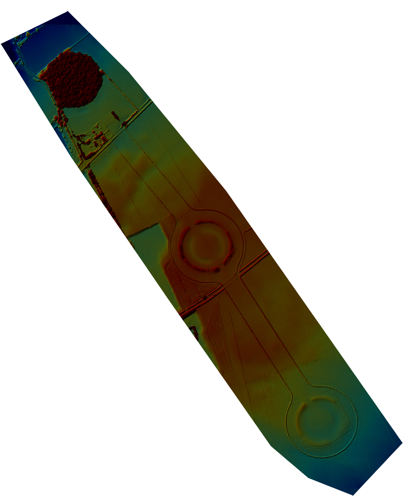
The orthomosaic photograph reveals the alignment in all its glory, taken on a cold but sunny midwinter day. However, the ground mapping image reveals that which was already known but rarely seen, namely that the Henges are not the first monuments on this site

Like many other ancient sites there is evidence in the elevation mapping shot here that the henges were constructed over banked alignments predating the bronze age henges.

These banks, or Cursus can clearly be seen crossing the henge alignments at right angles between the North and center henges, and again between the central and southern henge.

The purpose of these Cursus are as mysterious, if not more so, than the purpose of the henges themselves.

The fields surrounding the Thornborough henges are covered with bronze age burial mounds, illustrating a desire by supposed Head Men to be buried within sight of these mysterious constructions. 

The modern quarrying activities have caused great consternation locally and nationally with there being little consideration for the preservation of such remarkable monuments.
​
Click the button below for the HD Aerial Shot
CLICK HERE FOR AN HD ORTHOMOSAIC IMAGE AS A .TIFF FILE
Click the button below for the
​Elevation projection
CLICK HERE FOR AN ELEVATION PROJECTION FILE AS A .TIFF
Click below for the KML files for
​Google Earth Import
KML Files

Picture
Picture
Powered by Create your own unique website with customizable templates.
  • Survey Library
    • Medieval Castles & Villages >
      • Middleham Old Castle
      • Marton cum Grafton
      • Wharram Percy
      • Lead Chapel And DMV
      • East Tanfield DMV
      • North Deighton Motte & Bailey
      • Topcliffe Castle
    • Bronze Age Barrows & Enclosures >
      • Kipling House Farm
    • Henges and Barrows >
      • Nunwick Henge
      • Thornborough Henges
      • Cana Barn Henge
      • Hutton Moor Henge
      • Langthorpe Earthworks
    • Abbeys and Islands >
      • Jervaulx Abbey
      • Ellerton Priory
      • Little Ouseburn Tunulii
      • St. Cuthberts Island
    • Iron Age & Roman >
      • Stanwick Iron Age Fortifications
      • Newton Kyme Roman Fort
    • Battlefields >
      • Marston Moor
      • Agincourt Battlefield
  • Home
  • Our Services
  • Jon Kenny
  • Contact
  • Calendar
  • Droning on in our Blog